ATC routes on the airport's published taxi network and holds aircraft short at every runway exit, painted or not.
Auto-published from the airport design · for Microsoft Flight Simulator only - not for real-world navigation.
Auto-published plate
Fareham - Solent Gateway (BLU3)
ILS RWY 27
LOC 110.10 · IJAN
LOC
110.10 IJAN
FINAL CRS
266°M
GS / TCH
3.0° / 52′
DA (CAT I)
220′ (196′)
TDZE
24′
APT ELEV
55′
Missed approach: climb on track 266°M to 3,100′, then direct MA27 (IJAN DME 5.8 on the localizer course) and hold, right turns, 1-minute legs, inbound 266°M, maintain 3,100′.Notes: DME or GPS required. Missed-approach hold at MA27 is identified by IJAN DME on the localizer course.
Plan view · north up · not for navigation
Profile view · not to scale
Straight-in minimums
CAT I DA(H)
220′ (196′)
RVR / VIS
550 m / 1,800 ft
Runway & lighting
RWY 27
5,906′ · tarmac
Lighting
MALSR · PAPI 3.0° · edge
Auto-published from the airport design · for Microsoft Flight Simulator only — not for real-world navigation.
Auto-published plate
Fareham - Solent Gateway (BLU3)
VOR/DME RWY 27
VOR 116.00 · BLU
VOR
116.00 BLU
FINAL CRS
266°M
GP / TCH
3.0° / 52′
MDA
480′ (456′)
TDZE
24′
APT ELEV
55′
Missed approach: climb on track 266°M to 3,100′, then direct VM27 (BLU DME 5.3) and hold, right turns, 1-minute legs, inbound 266°M, maintain 3,100′.Notes: DME required. All fixes are radial/DME off BLU.
Plan view · north up · not for navigation
Profile view · not to scale
VF27 to MAP · 5.0 NM
Gnd speed kt
70
90
100
120
140
Time
4:17
3:20
3:00
2:30
2:09
Straight-in minimums
VOR/DME MDA(H)
480′ (456′)
VIS
1,600 m / 1 SM
Runway & lighting
RWY 27
5,906′ · tarmac
Lighting
PAPI
Auto-published from the airport design · for Microsoft Flight Simulator only — not for real-world navigation.
Auto-published plate
Fareham - Solent Gateway (BLU3)
NDB RWY 27
NDB 350 kHz · PRS
NDB
350 kHz PRS
FINAL CRS
266°M
GP / TCH
3.0° / 52′
MDA
540′ (516′)
TDZE
24′
APT ELEV
55′
Missed approach: climb on track 266°M to 3,100′, then RIGHT turn direct PRS NDB and hold, right turns, 1-minute legs, inbound 266°M, maintain 3,100′.Notes: ADF required. The beacon carries no DME - identify NF27 to MAP by timing (table below) or GPS distance. Course reversal at NI27; the missed approach returns to the PRS beacon - the whole procedure flies on the ADF alone.
Plan view · north up · not for navigation
Profile view · not to scale
NF27 to MAP · 5.0 NM
Gnd speed kt
70
90
100
120
140
Time
4:17
3:20
3:00
2:30
2:09
Straight-in minimums
NDB MDA(H)
540′ (516′)
VIS
1,600 m / 1 SM
Runway & lighting
RWY 27
5,906′ · tarmac
Lighting
PAPI
Auto-published from the airport design · for Microsoft Flight Simulator only — not for real-world navigation.
Auto-published plate
Fareham - Solent Gateway (BLU3)
VOR/DME RWY 09
VOR 116.00 · BLU
VOR
116.00 BLU
FINAL CRS
086°M
GP / TCH
3.0° / 52′
MDA
480′ (456′)
TDZE
24′
APT ELEV
55′
Missed approach: climb on track 086°M to 3,100′, then direct VM09 (BLU DME 5.7) and hold, right turns, 1-minute legs, inbound 086°M, maintain 3,100′.Notes: DME required. All fixes are radial/DME off BLU.
Plan view · north up · not for navigation
Profile view · not to scale
VF09 to MAP · 5.0 NM
Gnd speed kt
70
90
100
120
140
Time
4:17
3:20
3:00
2:30
2:09
Straight-in minimums
VOR/DME MDA(H)
480′ (456′)
VIS
1,600 m / 1 SM
Runway & lighting
RWY 09
5,906′ · tarmac
Lighting
PAPI
Auto-published from the airport design · for Microsoft Flight Simulator only — not for real-world navigation.
Auto-published plate
Fareham - Solent Gateway (BLU3)
NDB RWY 09
NDB 350 kHz · PRS
NDB
350 kHz PRS
FINAL CRS
086°M
GP / TCH
3.0° / 52′
MDA
540′ (516′)
TDZE
24′
APT ELEV
55′
Missed approach: climb on track 086°M to 3,100′, then RIGHT turn direct PRS NDB and hold, right turns, 1-minute legs, inbound 086°M, maintain 3,100′.Notes: ADF required. The beacon carries no DME - identify NF09 to MAP by timing (table below) or GPS distance. Course reversal at NI09; the missed approach returns to the PRS beacon - the whole procedure flies on the ADF alone.
Plan view · north up · not for navigation
Profile view · not to scale
NF09 to MAP · 5.0 NM
Gnd speed kt
70
90
100
120
140
Time
4:17
3:20
3:00
2:30
2:09
Straight-in minimums
NDB MDA(H)
540′ (516′)
VIS
1,600 m / 1 SM
Runway & lighting
RWY 09
5,906′ · tarmac
Lighting
PAPI
Auto-published from the airport design · for Microsoft Flight Simulator only — not for real-world navigation.
Auto-published plate
Fareham - Solent Gateway (BLU3)
VOR/DME RWY 31
VOR 116.00 · BLU
VOR
116.00 BLU
FINAL CRS
311°M
GP / TCH
3.0° / 52′
MDA
500′ (466′)
TDZE
34′
APT ELEV
55′
Missed approach: climb on track 311°M to 3,100′, then direct VM31 (BLU DME 5.2) and hold, right turns, 1-minute legs, inbound 311°M, maintain 3,100′.Notes: DME required. All fixes are radial/DME off BLU.
Plan view · north up · not for navigation
Profile view · not to scale
VF31 to MAP · 5.0 NM
Gnd speed kt
70
90
100
120
140
Time
4:17
3:20
3:00
2:30
2:09
Straight-in minimums
VOR/DME MDA(H)
500′ (466′)
VIS
1,600 m / 1 SM
Runway & lighting
RWY 31
5,906′ · asphalt
Lighting
as installed
Auto-published from the airport design · for Microsoft Flight Simulator only — not for real-world navigation.
Auto-published plate
Fareham - Solent Gateway (BLU3)
NDB RWY 31
NDB 350 kHz · PRS
NDB
350 kHz PRS
FINAL CRS
311°M
GP / TCH
3.0° / 52′
MDA
540′ (506′)
TDZE
34′
APT ELEV
55′
Missed approach: climb on track 311°M to 3,100′, then RIGHT turn direct PRS NDB and hold, right turns, 1-minute legs, inbound 311°M, maintain 3,100′.Notes: ADF required. The beacon carries no DME - identify NF31 to MAP by timing (table below) or GPS distance. Course reversal at NI31; the missed approach returns to the PRS beacon - the whole procedure flies on the ADF alone.
Plan view · north up · not for navigation
Profile view · not to scale
NF31 to MAP · 5.0 NM
Gnd speed kt
70
90
100
120
140
Time
4:17
3:20
3:00
2:30
2:09
Straight-in minimums
NDB MDA(H)
540′ (506′)
VIS
1,600 m / 1 SM
Runway & lighting
RWY 31
5,906′ · asphalt
Lighting
as installed
Auto-published from the airport design · for Microsoft Flight Simulator only — not for real-world navigation.
Auto-published plate
Fareham - Solent Gateway (BLU3)
VOR/DME RWY 13
VOR 116.00 · BLU
VOR
116.00 BLU
FINAL CRS
131°M
GP / TCH
3.0° / 52′
MDA
500′ (466′)
TDZE
34′
APT ELEV
55′
Missed approach: climb on track 131°M to 3,100′, then direct VM13 (BLU DME 5.8) and hold, right turns, 1-minute legs, inbound 131°M, maintain 3,100′.Notes: DME required. All fixes are radial/DME off BLU.
Plan view · north up · not for navigation
Profile view · not to scale
VF13 to MAP · 5.0 NM
Gnd speed kt
70
90
100
120
140
Time
4:17
3:20
3:00
2:30
2:09
Straight-in minimums
VOR/DME MDA(H)
500′ (466′)
VIS
1,600 m / 1 SM
Runway & lighting
RWY 13
5,906′ · asphalt
Lighting
as installed
Auto-published from the airport design · for Microsoft Flight Simulator only — not for real-world navigation.
Auto-published plate
Fareham - Solent Gateway (BLU3)
NDB RWY 13
NDB 350 kHz · PRS
NDB
350 kHz PRS
FINAL CRS
131°M
GP / TCH
3.0° / 52′
MDA
540′ (506′)
TDZE
34′
APT ELEV
55′
Missed approach: climb on track 131°M to 3,100′, then RIGHT turn direct PRS NDB and hold, right turns, 1-minute legs, inbound 131°M, maintain 3,100′.Notes: ADF required. The beacon carries no DME - identify NF13 to MAP by timing (table below) or GPS distance. Course reversal at NI13; the missed approach returns to the PRS beacon - the whole procedure flies on the ADF alone.
Plan view · north up · not for navigation
Profile view · not to scale
NF13 to MAP · 5.0 NM
Gnd speed kt
70
90
100
120
140
Time
4:17
3:20
3:00
2:30
2:09
Straight-in minimums
NDB MDA(H)
540′ (506′)
VIS
1,600 m / 1 SM
Runway & lighting
RWY 13
5,906′ · asphalt
Lighting
as installed
Auto-published from the airport design · for Microsoft Flight Simulator only — not for real-world navigation.
Auto-published plate
Fareham - Solent Gateway (BLU3)
VOR-A
VOR 116.00 · BLU · CIRCLING
VOR
116.00 BLU
FINAL CRS
311°M
GP
3.0° to MDA
MDA(H)
Circle-to-land
TDZE
55′
APT ELEV
55′
Missed approach: climb on track 311°M to 3,100′, then LEFT turn direct BLU and hold, LEFT turns, 1-minute legs, inbound 311°M, maintain 3,100′.Notes: CIRCLING ONLY - the final approach course serves no runway; circle to land visually. DME required. MAP at BLU VOR.
Plan view · north up · not for navigation
Profile view · not to scale
VFA to MAP · 5.0 NM
Gnd speed kt
70
90
100
120
140
Time
4:17
3:20
3:00
2:30
2:09
Circle-to-land minimums (MDA(H) · VIS)
CAT A (<91 kt)
420′ (365′) · 1 SM
CAT B (91-120 kt)
520′ (465′) · 1 SM
CAT C (121-140 kt)
520′ (465′) · 1½ SM
CAT D
NA
Runway & lighting
Longest RWY
5,906′ · tarmac
Lighting
as installed
Auto-published from the airport design · for Microsoft Flight Simulator only — not for real-world navigation.
Auto-published plate
Fareham - Solent Gateway (BLU3)
NDB-B
NDB 350 kHz · PRS · CIRCLING
NDB
350 kHz PRS
FINAL CRS
311°M
GP
3.0° to MDA
MDA(H)
Circle-to-land
TDZE
55′
APT ELEV
55′
Missed approach: climb on track 311°M to 3,100′, then LEFT turn direct PRS NDB and hold, LEFT turns, 1-minute legs, inbound 311°M, maintain 3,100′.Notes: CIRCLING ONLY - the final approach course serves no runway; circle to land visually. ADF required; fly the final by timing (table below). MAP overhead the PRS beacon.
Plan view · north up · not for navigation
Profile view · not to scale
NFB to MAP · 5.0 NM
Gnd speed kt
70
90
100
120
140
Time
4:17
3:20
3:00
2:30
2:09
Circle-to-land minimums (MDA(H) · VIS)
CAT A (<91 kt)
420′ (365′) · 1 SM
CAT B (91-120 kt)
520′ (465′) · 1 SM
CAT C (121-140 kt)
520′ (465′) · 1½ SM
CAT D
NA
Runway & lighting
Longest RWY
5,906′ · tarmac
Lighting
as installed
Auto-published from the airport design · for Microsoft Flight Simulator only — not for real-world navigation.
From the builder
BLU3 · in Microsoft Flight Simulator 2024
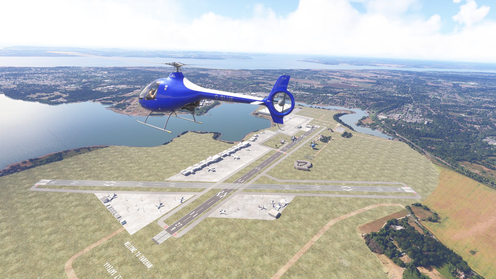
The story of Fareham - Solent Gateway
Fareham - Solent Gateway. The South Coasts premier destination for international, regional and cargo flights. Why not visit 'The Pieful Tower' for a coffee and a dessert or stay at our luxurious on site hotel. BLU3 is perfectly situated as the arrival or departure point for some Coastal Cruising.
- BaldPaul1978
Field radio
Comments
5 transmissions
S
SAVCOM
nice expansion, hope to do similar, soon to level 3 and longer runway..great, be back. VTCS12
S
SAVCOM
This is really good, you have moved into my top favourite to visit. Can`t wait to see what`s coming. SAV1
S
SAVCOM
thanks for the visit, been awhile, hope to see you more often
B
BaldPaul1978
Yeah, not managed to get on a whole lot lately but I'll certainly try. Hope you're well
S
SAVCOM
yes, plodding along, trying to crack these badges, some eye raising airports out there.
Join the field radio
Sign in on the web to comment - Discord isn't required.
Fly Fareham - Solent Gateway BLU3 in your own sim.
Install the free companion app and BLU3 - plus every airport on Project Airports - drops straight into Microsoft Flight Simulator 2024 and stays up to date. No SDK, no DevMode, no file wrangling.



Comments
SAVCOM
nice expansion, hope to do similar, soon to level 3 and longer runway..great, be back. VTCS12
SAVCOM
This is really good, you have moved into my top favourite to visit. Can`t wait to see what`s coming. SAV1
SAVCOM
thanks for the visit, been awhile, hope to see you more often
BaldPaul1978
Yeah, not managed to get on a whole lot lately but I'll certainly try. Hope you're well
SAVCOM
yes, plodding along, trying to crack these badges, some eye raising airports out there.
Join the field radio
Sign in on the web to comment - Discord isn't required.