
Community airport · Live view

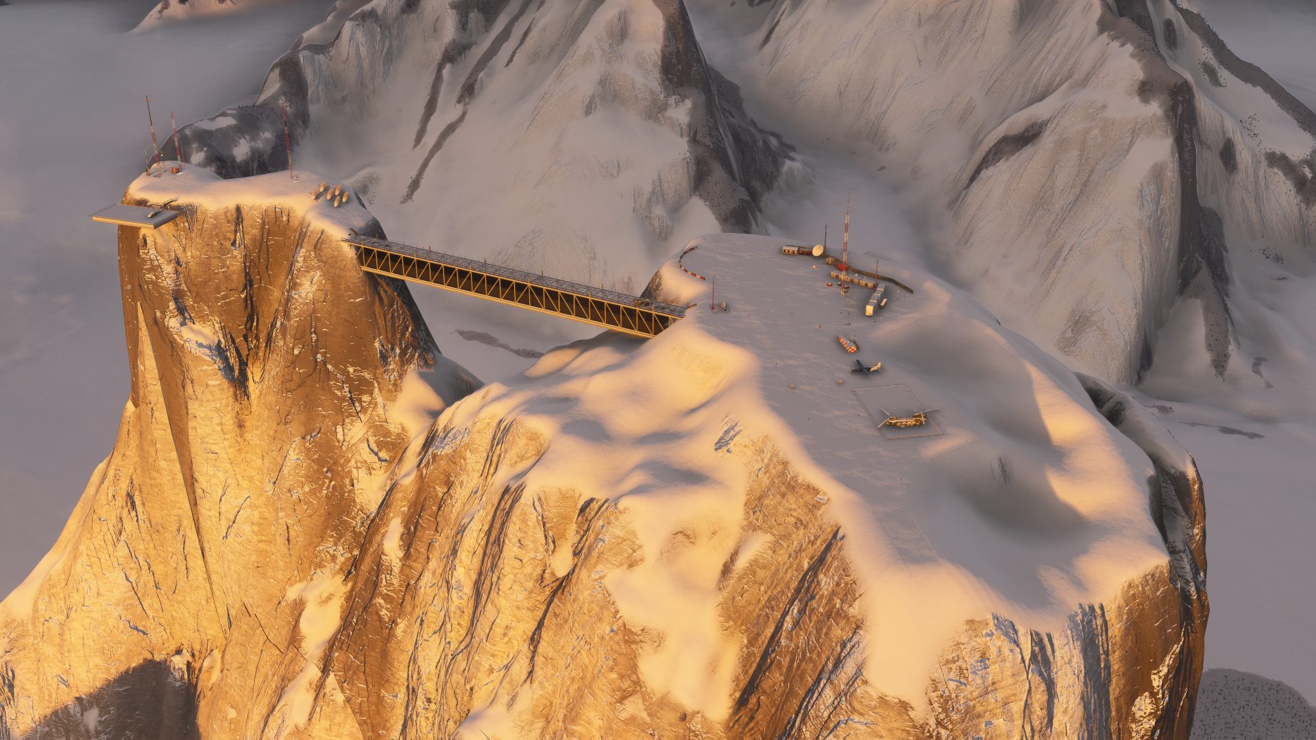
Mt Asgard Research Station CAS9

Built by 30golf · Established August 2026

Project SupporterThis builder helps keep Project Airports flying.
Fly this - get the free app

Free · installs CAS9 into MSFS 2024

Live Airport ViewCAS9 · Mt Asgard Research Station

[ loading airport… ]

HDG ---°
live traffic · quiet skies
Drag to look around · flat view by default · 3D terrain and orbit optional · flyable in Microsoft Flight Simulator 2024

Runway

1

Longest strip

984 ft dirt

Placed objects

82

Field elevation

6,570 ft

RNAV RWY A · 0.40 (AS) · CRS 325° · GP 3.0° · NDB 400 kHz (AS) · charts linked

Instrument procedures

NDB-A

On-field navaids: NDB 400 kHz (AS)

1 / 1Open / print

Auto-published plate

Mt Asgard Research Station (CAS9)

Project Airports

NDB-A

NDB 400 kHz · AS · CIRCLING

NDB

400 kHz AS

FINAL CRS

325°M

GP

3.0° to MDA

MDA(H)

Circle-to-land

TDZE

6,570′

APT ELEV

6,570′

Missed approach: climb on track 325°M to 8,600′, then LEFT turn direct AS NDB and hold, LEFT turns, 1-minute legs, inbound 325°M, maintain 8,600′.
Notes: CIRCLING ONLY - the final approach course serves no runway; circle to land visually. ADF required; fly the final by timing (table below). MAP overhead the AS beacon.

Plan view · north up · not for navigation

1 MINNIA10.2 NMNFA5.2 NM325°MAS8,600′400 kHzASN2 NM

Profile view · not to scale

MAP AS8,270′GP 3.0°MDA 7,080′MNIA1 MIN10.2 NMNFA5.2 NM8,600′

NFA to MAP · 5.2 NM

Gnd speed kt7090100120140
Time4:263:273:062:352:13

Circle-to-land minimums (MDA(H) · VIS)

CAT A (<91 kt)7,080′ (510′) · 1 SM
CAT B (91-120 kt)7,180′ (610′) · 1 SM
CAT C (121-140 kt)7,180′ (610′) · 1½ SM
CAT DNA

Runway & lighting

Longest RWY984′ · dirt
Lightingas installed

Auto-published from the airport design · for Microsoft Flight Simulator only — not for real-world navigation.
← CAS9
From the builder
Mt Asgard Research Station (CAS9) in Microsoft Flight Simulator 2024
CAS9 · in Microsoft Flight Simulator 2024

The story of Mt Asgard Research Station

Mt. Asgard Research Station is located on the flat summit of Mt. Asgard in Northern Canada, which hosts one of the world's tallest vertical cliffs. This airfield requires expert pilots, as the landing strip is just under 1000 ft long surrounded by 5000 ft cliffs on all sides. AIRPORT BRIEFING: Runway 15/33: 984 ft (300 m), snow surface year round. Landing 33: Use caution for rocks just before the threshold. Aircraft MUST be stationary by the time they are abeam the Canadian flag in order to be able to turn around. If still in motion when reaching the flag, go around. (Note: thanks to the 5000 ft cliff, go around can be safely executed even at very low speeds.) Landing 15: Not advised. 15 arrivals MUST be stationary by the wind sock (LDA: 500 ft) to be able to safely turn into the parking spot. If still in motion when reaching the wind sock, go around. Aircraft MUST rotate prior to the end of the runway to avoid rocks off the departure end. Takeoff 15: Not advised. Aircraft MUST rotate prior to the end of the runway to avoid rocks off the departure end. Takeoff 33: Thanks to the 5000 ft cliff, takeoff can be safely executed from any point on the runway prior to the Canadian flag, and at essentially any airspeed. DO NOT backtaxi past the signs; there is no room to make the 180, so the aircraft will need to be pushed back. Helicopters: Both helipads are available for helicopters of any size. Other Notes: Use caution for the many tall antennae on the mountaintop near the airstrip and helipads.

- 30golf

Field radio

Comments

0 transmissions

The frequency is quiet

Be the first to leave a note for the builder or a tip for visiting pilots.

Join the field radio

Sign in on the web to comment—Discord isn't required.

Sign in to comment

Fly Mt Asgard Research Station CAS9 in your own sim.

Install the free companion app and CAS9 - plus every airport on Project Airports - drops straight into Microsoft Flight Simulator 2024 and stays up to date. No SDK, no DevMode, no file wrangling.